

Hydropower Potential Analysis and Location Decision Support System.

HydroLoc is a GIS-based toolset to estimate and analyse the small and medium hydropower potentials. It uses digital terrain data, hydrographic and landuse data, as well as hydrologic models to identify and rank potential power plant sites of various design capacity with a high resolution for entire countries, regions or catchments.
HydroLoc results are presented problem-oriented in maps and tables. The following standard informations are generated:
- Overview maps showing hydroelectric potential river by river for the selected region.
- Hydroelectric potential maps showing potentials, and including limiting factors in the analysis, such as already developed sites, protected areas, etc.
- Detailed Indicative maps of hydropower plant sites, of a chosen design capacity, including ranking results for preferential site development.
- Characterization of each potential power plant in a Site report containing detailed technical, hydrological, economical and ecological information.
Visualisation tools:
- Digital Atlas containing all generated documents in PDF format
- WebGIS with ArcGIS Server
- Google Earth Application
The theoretical hydroelectric potential of a water course (stream) is determined primarily by topographical and hydrological characteristics. These are, namely, the runoff as a result of the catchment area’s surface, and the longitudinal profile (downward slope) of a stream.
The use of the hydroelectric potential is limited due to already developed hydropower as well as in areas with excluding factors like natural areas protected by the government, archaeological zones, zones with no access, and others. The conceptual approach for computing the hydroelectric potential is explained and illustrated in the following section.
Conceptual Approach
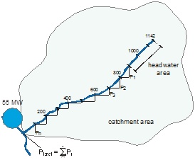 |
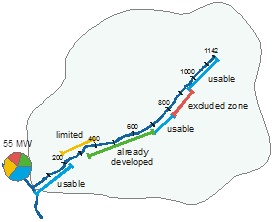
Determination of the theoretical hydroelectric potential A stream is divided into equidistant segments. The hydroelectric potential for each segment can be derived from its catchment area, runoff, and downward slope. By summing up the potentials of each segment of a stream, its theoretical hydroelectric potential can be calculated and displayed as a circle diagram. The diagram area is proportional to the hydroelectric capacity. The runoff calculation is based on the average natural runoff with no anthropogenic influences. |
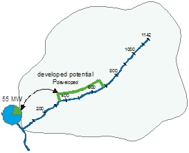 |
Taking into account the developed potential Utilizing a stream for energy production is subject to authorization and legally regulated through licenses.
The available energy potential results from subtracting the developed hydroelectric potential (green section of diagram) from the total theoretical hydroelectric potential. |
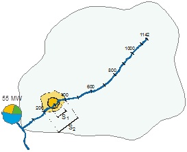 |
Taking into account limiting factors The theoretical hydroelectric potential may be further reduced by several limiting factors.
Limiting factors may impede hydropower utilization, but do not make it completely impossible. Limiting factors are taken into account by means of a spatial intersection in a GIS. Distances between spatial influences and streams can also be taken into consideration. |
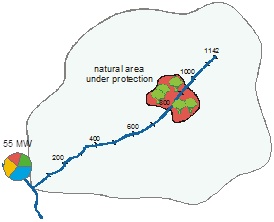 |
Taking into account excluding zones Excluding zones (such as natural areas protected by the government or others) do not allow for any hydropower utilization. They are also taken into account by means of a spatial intersection in a GIS.
When both developed potential and excluding zones have been taken into account, the available (feasible) hydroelectric potential remains (blue section of diagram). |
 |
Results This conceptual approach provides the following information for all streams:
• Hydroelectric potential for stream segments (high resolution, 200m segment length) • Theoretical hydroelectric potential for whole streams • Potential percentages (developed, limited, excluded, usable) Potential percentages are represented in the diagrams through the use of different colours. |
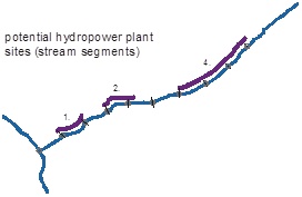 |
Determining potential sites for hydropower plants Based on the detailed knowledge of the stream segments’ hydroelectric potential, developed potential and excluding zones all possible sites for hydropower plants are identified. Ranking the potential sites will led to the 100 best sites. Arbitrary factors can be chosen for the ranking (e.g. residual flow reach length, or gross head). |
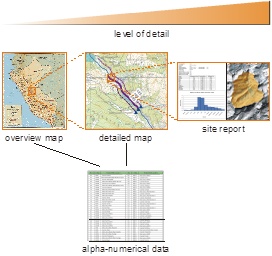 |
Presentation of results Results are presented problem-oriented in cartographic and tabular form. For the cartographic representation a scale-dependent approach is chosen. Results are displayed as:
• Overview maps showing hydroelectric potentials and potential sites for administrative or hydrographic regions, etc. • Detailed maps showing the hydroelectric potentials, developed potentials and influencing factors for all streams. • Detailed map of potential power plant sites, including ranking results, infrastructure, etc. • Site report for each potential power plant (PDF) • Digital Atlas containing all documents mentioned above (PDF) • Internet GIS prospector based on ArcGIS Server • Google Earth Application. |
Data Model
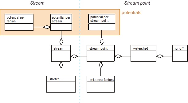
The data model, which has been designed to be extensible, provides a way to store analysis results and important intermediate results without any redundancy. A simplified version of it is shown as an entity-relationship diagram (ERD). Entities associated with stream points have been placed on the right-hand side of the blue separation line, while those associated with streams are shown on the left-hand side. Entities which contain information about hydroelectric potentials, and which are therefore the basis for presenting tabular and graphical results, have been highlighted in orange.
Method of Computation
All analyses are performed inside a GIS. Topographic and hydrological data as well as GIS data for the influencing factors are first being prepared according to the needs and then transferred into a geo-database. In a geo-database, geometric data can be managed and used along with alpha-numerical information for spatial analyses.
 |
Base data preparation• Providing runoff data for the project area. A precipitation raster dataset is created from TRMM data having a high spatial and temporal resolution, and by consideration of the 457 meteorological stations. Current evaporation is computed through a physical N/A model by taking into account land use and the topographical situation. The result of this modelling process is an area-wide raster dataset of the mean monthly runoff.
• Geometric runoff conditions are simulated by using the digital elevation model (DEM). • Prepare GIS layers for influence factors. (limited, excluded, developed) • Prepare GIS layer for locations and technical data of existing hydropower plants in Peru |
 |
Definition of discrete stream pointsAll streams are partitioned into equidistant segments. Based on a sensitivity analysis and the spatial resolution of the DEM a segment length of 200 m has been chosen. Each segment is represented by a point (start point of segment). For each of these discrete points on a stream, a corresponding measure point is located on the associated generic stream. For each stream point its altitude is derived from the DEM. |
 |
Runoff calculationFor each discrete stream point, the average natural monthly runoff is calculated by spatially intersecting the catchment area’s geometry with the raster runoff datasets that have been prepared.
There are 12 raster datasets in total: one for each month’s average natural runoff. |
 |
Estimation of the theoretical hydroelectric potentialThe theoretical hydroelectric potential is computed for each stream segment (having a length of normally 200 m). The total potential for a complete stream can be derived by summing up the potentials of its single segments. By storing analysis results in the database at such a high resolution, it remains possible to conduct different evaluations later on, should requirements change. The theoretical hydroelectric potential is being estimated on the basis of natural runoff with no anthropogenic influences. |
 |
Identification of potential sites for power plantsBased on the theoretical hydroelectric potentials computed for each 200 m stream segment, all potential sites for hydropower plants are identified.
Based on the detailed knowledge of the stream segments’ hydroelectric potential, developed potential and excluding zones all possible sites for hydropower plants are identified. Ranking the potential sites will lead to the 100 best sites. Arbitrary factors can be chosen for the ranking (e.g. residual flow reach length, or gross head, technical feasibility, infrastructure components, economical aspects). |
Decision support
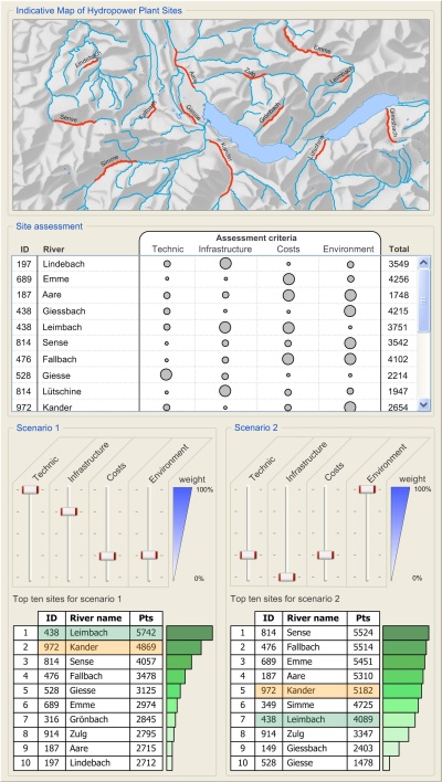
Based on the detailed knowledge of the hydroelectric potential of each stream, potential hydropower sites with various capacities (several kW to 100 MW) can be identified and displayed in the indicative map of hydropower plant sites.
HydroLoc supports the site assessment through an integrated Decision Support System. The DSS allows the introduction of various decision criteria which can be defined by the customer.
Different scenarios are easily created by simply selecting and weighing the different decision criterias.
For each scenario it is possible to identify and rank the most suitable locations.